Great Smoky Mountain Elevations
From about 875 feet in the valleys to 6,643 at the highest peak — a range that shapes the temperature, the forests, and the wildlife at every level. Here's what sits where, and what it means for your trip.
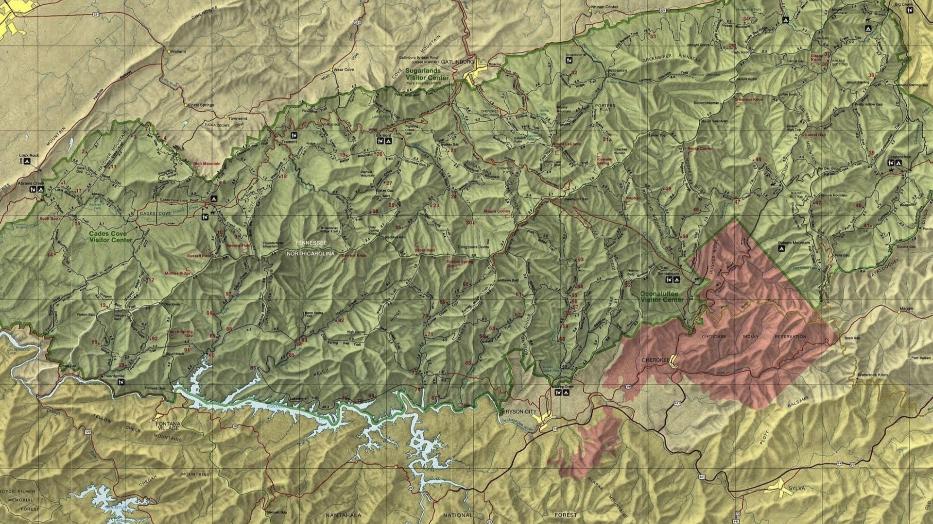
The Great Smokies climb from about 875 feet in the valleys to 6,643 feet at the highest peak — and that range is the single biggest reason this is one of the most biodiverse regions in North America.
Elevation shapes everything here: the temperature, the rainfall, the trees, the wildlife. Drive from Gatlinburg to Newfound Gap and you pass through the ecological equivalent of a thousand-mile journey north. Here's what sits at each level, and what it means for your visit.
Quick reference
| Location | Elevation | What it means |
|---|---|---|
| Sevierville | 902 ft | Flattest of the gateway towns |
| Pigeon Forge | 1,001 ft | Gently rolling terrain |
| Gatlinburg | 1,289 ft | Ringed by much higher peaks |
| Wears Valley | 1,454 ft | Rural, with wide mountain views |
| Cades Cove | 1,800 ft | Mild climate, heavy wildlife |
| Alum Cave trailhead | 3,800 ft | Noticeably cooler than town |
| Newfound Gap | 5,046 ft | Spruce-fir forest begins |
| Mount Le Conte | 6,593 ft | Third-highest in the park |
| Kuwohi | 6,643 ft | Highest point in the Smokies |
Temperature drops roughly 3.5°F for every 1,000 feet you climb. A 75-degree afternoon in Gatlinburg is closer to 55 at Kuwohi — and that's before wind. Bring a layer even on a warm day if you're driving up.
Low elevations: 875 to 2,000 feet
The lowest ground sits near the park entrances and through the surrounding valleys — warmer, more humid, and covered in lush temperate deciduous forest. This is where most visitors spend their time, and where the cabins are.
Cades Cove — 1,800 feet
A broad valley ringed by mountains, and one of the most popular places in the park. The relatively low elevation gives it a mild climate that supports the hardwood forests around the cove. Historic buildings, the Abrams Falls trail, and reliable wildlife — deer, black bears, wild turkeys.
Little River Road — 1,200 to 1,800 feet
Running alongside the Little River from Sugarlands toward the Townsend entrance, with access to Laurel Falls among others. The low elevation and river proximity make it thick with rhododendron, ferns, and everything else that likes moisture.
Mid elevations: 2,000 to 4,000 feet
The forest starts shifting here — hardwoods mixing with conifers, and the temperature dropping enough to notice. Most of the park's best-known trails start in this band.
Alum Cave trailhead — 3,800 feet
On Newfound Gap Road, and the start of one of the most popular hikes in the Smokies. The trail climbs to Alum Cave Bluffs and continues to the summit of Mount Le Conte. Mixed hardwoods and evergreens along the way, with wildflowers through spring and summer.
Roaring Fork Motor Nature Trail — 2,000 to 3,000 feet
A one-way loop through hemlock, yellow birch, and maple, climbing about a thousand feet across its length. Access to several trails including Rainbow Falls. The elevation and rainfall make it especially green — moss-covered rock and rushing water most of the way.
High elevations: 4,000 to 6,643 feet
This is where it gets dramatic. Spruce and fir take over, the temperature drops sharply, precipitation increases, and snow is common in winter.
Newfound Gap — 5,046 feet
The most accessible high point in the park, on US-441 crossing the Smokies north to south. Panoramic views, and a major trailhead — the Appalachian Trail crosses here, and the road to Kuwohi begins nearby. The cooler, wetter conditions support Southern Appalachian spruce-fir forest.
Kuwohi — 6,643 feet
The highest point in the Great Smokies and the third-highest peak east of the Mississippi. Formerly known as Clingmans Dome, the mountain was officially restored to its Cherokee name, Kuwohi, in 2024.
On a clear day the views from the observation tower reach a hundred miles. Temperatures typically run ten to twenty degrees below the valleys, and the surrounding spruce-fir forest is more characteristic of Canada than Tennessee. The tower is reached by a steep, paved half-mile walk from the parking area — short, but genuinely steep.
Mount Le Conte — 6,593 feet
Fifty feet lower than Kuwohi and arguably the more iconic climb. Several trails reach the summit; Alum Cave is the shortest and most popular. The elevation creates a cool, damp environment where rare plants and animals persist. Sunrise and sunset from the top are the reason people make the effort.
How elevation shapes the ecosystem
Moving from valley to peak takes you through distinct forest zones, each supporting different life.
- Deciduous forest at lower elevations — oak, hickory, and maple in warm temperatures and rich soil, with deer, bears, and a wide range of birds
- Mixed mesophytic forest in the mid-range — deciduous trees mixing with hemlock and pine, and ideal conditions for rhododendron, mountain laurel, and wildflowers
- Spruce-fir forest above roughly 4,500 feet — red spruce and Fraser fir, remnants of the Ice Age and more typical of far northern latitudes. This zone supports species found nowhere else in the park, including the endangered spruce-fir moss spider and several rare salamanders
Elevation and climate
The 3.5-degree drop per thousand feet has real consequences. High elevations see snow and ice well into spring, while the valleys are mild. It's why Newfound Gap Road closes in winter storms when Gatlinburg is merely wet.
The frequent fog and mist at altitude is where the name comes from — those are the "smokes." That moisture is also what keeps the high-elevation ecosystems alive.
The gateway towns
The four towns sit at noticeably different heights, which shapes their character as much as their weather.
- Sevierville — 902 feet. The gateway, and the flattest, opening gradually into mountain terrain as you head south
- Pigeon Forge — 1,001 feet. Gently rolling, a few miles north of Gatlinburg
- Gatlinburg — 1,289 feet. Low itself, but ringed by peaks rising to over 6,500 feet, which is why the views from town are what they are
- Wears Valley — 1,454 feet. The highest of the four, rural and quiet, with wide views of the surrounding mountains
Cabin elevation varies a lot within each town. Ridgeline properties sit hundreds of feet above the valley floor — better views, cooler evenings, and steeper driveways. See cabins with mountain views.
Frequently asked questions
What's the highest point in the Smokies?
Kuwohi, at 6,643 feet — the third-highest peak east of the Mississippi. It was formerly named Clingmans Dome and officially restored to its Cherokee name in 2024.
How much colder is it at the top?
Roughly 3.5°F cooler per thousand feet, which puts the high peaks ten to twenty degrees below the valleys. Wind at altitude makes the difference feel larger.
What elevation is Gatlinburg?
About 1,289 feet, though individual cabins in the surrounding hills sit considerably higher.
Why are the mountains called Smoky?
The fog and mist that collect at higher elevations, which look like smoke from below. It's a product of the moisture those ecosystems depend on.
Does elevation affect when I should visit?
Considerably. Fall color starts at the top and moves down over several weeks, so a late-October trip that seems past peak in the valleys may be perfect on the ridges. Winter snow at altitude is common when the towns see none. And a hot August afternoon is genuinely pleasant at Newfound Gap.
Are the high-elevation roads open year-round?
Newfound Gap Road closes during winter storms, and the road to Kuwohi closes seasonally. Check current park road status before planning a high-elevation drive between December and March.
Elevation is worth thinking about when you pick a cabin — a ridgeline property means better views and cooler evenings, and a valley one means an easier drive in winter. Browse our Gatlinburg, Pigeon Forge, Sevierville, and Wears Valley cabins, or go straight to cabins with mountain views and cabins near the national park. Check the current specials, or use the vacation planner to plan the trip.