Elevations in the Great Smoky Mountains: Complete Guide
Published Jan 13, 2026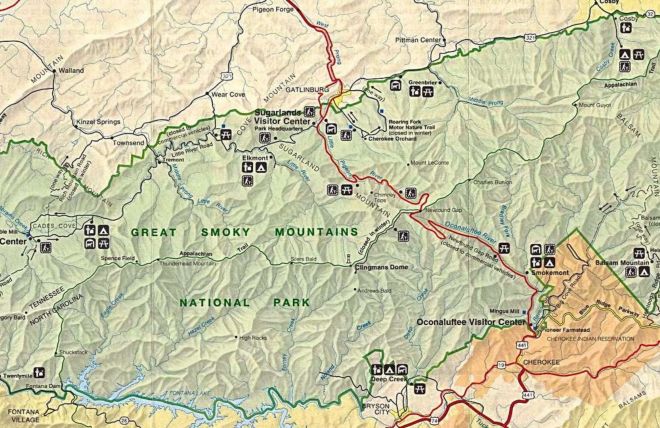
Great Smoky Mountains National Park spans an elevation range of nearly 5,800 feet — from river bottoms below 900 feet to a summit at 6,643 feet. That range is what gives the park its extraordinary biodiversity, its variable weather, and its dramatic temperature differences between valley towns and mountaintops. Here's the complete guide to elevations in the Smokies.
Gateway Cities — For Comparison
Most visitors don't realize how elevated the Smoky Mountains corridor already is before the national park even begins. The gateway cities sit significantly higher than most major eastern cities — Charlotte sits at 751 feet, Cincinnati at 489 feet, Atlanta at 1,050 feet.
| Location | Elevation | Notes |
|---|---|---|
| Sevierville | ~902 ft | Lowest of the three gateway cities; gateway to the Smokies corridor |
| Pigeon Forge | ~1,001 ft | Main Parkway corridor; Dollywood is located here |
| Gatlinburg (downtown) | ~1,289 ft | Highest of the three cities; sits at the national park entrance |
| Sugarlands Visitor Center | ~1,462 ft | At the edge of downtown Gatlinburg, already inside the park boundary |
Park Low Point
| Location | Elevation | Notes |
|---|---|---|
| Abrams Creek (lowest point) | 876 ft | The lowest elevation in the entire park, in the far western section near the North Carolina border |
Popular Trails and Road Locations
| Location | Elevation | Notes |
|---|---|---|
| Laurel Falls Trailhead | ~2,307 ft | Most visited waterfall trail in the park; paved, 2.6 miles round trip |
| Laurel Falls (the waterfall) | ~2,600 ft | The falls themselves sit noticeably higher than the trailhead |
| Alum Cave Trailhead | ~3,800 ft | Along Newfound Gap Road; access point for Mount LeConte |
| Newfound Gap | 5,048 ft | Major overlook on US-441; Tennessee/North Carolina border; Appalachian Trail crossing |
| Andrews Bald | 5,920 ft | Grassy mountain meadow; popular spring wildflower destination; 3.6 miles round trip from Kuwohi parking |
| Charlies Bunion | 5,565 ft | Rocky outcropping with panoramic views; 8 miles round trip from Newfound Gap |
| Balsam Mountain Campground | 5,310 ft | One of the highest drive-in campgrounds in the eastern US |
| Kuwohi Road (Clingmans Dome Road) — parking lot | ~6,311 ft | Highest paved road in the eastern US; closed in winter |
Major Peaks
| Peak | Elevation | Notes |
|---|---|---|
| Kuwohi (formerly Clingmans Dome) | 6,643 ft | Highest point in the park; highest point in Tennessee; highest point on the entire Appalachian Trail; observation tower accessible via 0.5-mile paved trail from parking lot |
| Mount Buckley | 6,560 ft | Western subpeak of Kuwohi; no maintained trail to summit |
| Mount Guyot | 6,621 ft | Second highest peak in the park; eastern Smokies; no maintained trail — requires bushwhack from Appalachian Trail |
| Mount LeConte | 6,593 ft | Third highest peak; highest peak entirely within Tennessee; tallest mountain in the range by vertical rise from base (5,301 ft from Gatlinburg); LeConte Lodge at the summit; accessible via five trails |
| Mount Love | 6,400 ft | Eastern subpeak of Kuwohi; Appalachian Trail passes nearby |
| Mount Chapman | 6,431 ft | Fourth highest peak; eastern Smokies; Appalachian Trail crosses eastern slope |
| Old Black | 6,370 ft | Fifth highest standalone peak; eastern Smokies near Mount Guyot |
| Mount Hardison | 6,145 ft | 13th highest in the park; North Carolina side; no maintained trail |
| Luftee Knob | 6,234 ft | Along the Appalachian Trail near the park's southeastern boundary |
| Cosby Knob | 5,160 ft | Accessible via Appalachian Trail; Cosby Knob Shelter nearby |
| Mount Sterling | 5,835 ft | Eastern Smokies; historic fire tower at the summit with 360-degree views |
| Shuckstack | 4,020 ft | Historic fire tower; southwestern corner of the park near Fontana Lake |
| Ober Gatlinburg summit | ~3,340 ft | Not a natural peak — the Ober Gatlinburg resort mountaintop; accessible by aerial tramway from downtown Gatlinburg |
What the Elevation Range Means in Practice
Temperature. Expect roughly 3–5°F of cooling for every 1,000 feet of elevation gain. On a 90°F summer day in Gatlinburg, Newfound Gap (5,048 ft) runs about 15–20°F cooler, and Kuwohi (6,643 ft) runs 20–25°F cooler. Bring a layer for any high-elevation destination regardless of the valley temperature.
Weather. The high-elevation ridges create their own weather. Clouds, mist, and rain arrive faster and stay longer at elevation. The summit of Kuwohi receives an average of over 85 inches of rainfall per year — more than twice the valley average. Snow is possible on the highest summits in any month of the year.
Biodiversity. The park's elevation range spans five distinct forest types — from cove hardwoods at the lowest elevations to Southern Appalachian spruce-fir forest above 4,500 feet — producing more tree species than all of northern Europe combined.
Altitude sickness. Most people aren't affected below 5,000 feet. At higher elevations — particularly for guests hiking from the valley — watch for headache, dizziness, or nausea. Hydrate, go slowly, and descend if symptoms develop.
Kuwohi Road closure. The road to the Kuwohi (Clingmans Dome) parking area is closed December 1 through March 31 each year.
Frequently asked questions
What is the highest point in Great Smoky Mountains National Park?
Kuwohi (formerly Clingmans Dome) at 6,643 feet — the highest point in Tennessee, the highest point on the entire 2,190-mile Appalachian Trail, and the third-highest peak in the eastern United States. An observation tower at the summit is accessible via a steep 0.5-mile paved trail from the parking area.
What is the elevation of Gatlinburg, Pigeon Forge, and Sevierville?
Gatlinburg sits at approximately 1,289 feet, Pigeon Forge at approximately 1,001 feet, and Sevierville at approximately 902 feet. All three are already significantly higher than most major eastern cities before you've entered the national park.
How much cooler is it at Kuwohi than in Gatlinburg?
Typically 20–25°F cooler. The elevation difference of roughly 5,354 feet between downtown Gatlinburg (1,289 ft) and Kuwohi's summit (6,643 ft) produces a dramatic temperature change — a mild 75°F day in Gatlinburg can mean near-freezing temperatures at the summit.
What is the lowest elevation in Great Smoky Mountains National Park?
Approximately 876 feet at Abrams Creek in the far western section of the park — making the park's total elevation range nearly 5,800 feet from bottom to summit.
Is Newfound Gap worth visiting?
Yes — at 5,048 feet, Newfound Gap is the most accessible high-elevation viewpoint in the park, directly on US-441 with no additional hiking required. The overlook sits on the Tennessee/North Carolina border with panoramic mountain views in both directions. The Appalachian Trail crosses the road here.
Can altitude sickness occur in the Smoky Mountains?
Mild altitude effects are possible above 5,000 feet, particularly for guests hiking from lower elevations. Headache, dizziness, and nausea are the most common symptoms. Staying hydrated, hiking at a moderate pace, and descending if symptoms develop are the right responses. Severe altitude sickness is rare at Smokies elevations.
Use Gatlinburg or Pigeon Forge as your base — a private cabin puts you within minutes of every elevation on this list, from valley river walks to the road to Kuwohi.