Rocky Top
Cades Cove · 13.9 miles round trip, strenuous
Most high points in the Smokies are wooded, and you reach the top to find nothing to look at. Rocky Top is bare rock on an open ridge with Tennessee falling away on one side and North Carolina on the other. Getting there costs roughly fourteen miles and 3,600 feet of climbing from the Cades Cove picnic area. If the day runs long, Spence Field — the grassy bald about a mile short of the summit — is a fair place to stop and still go home having seen something.
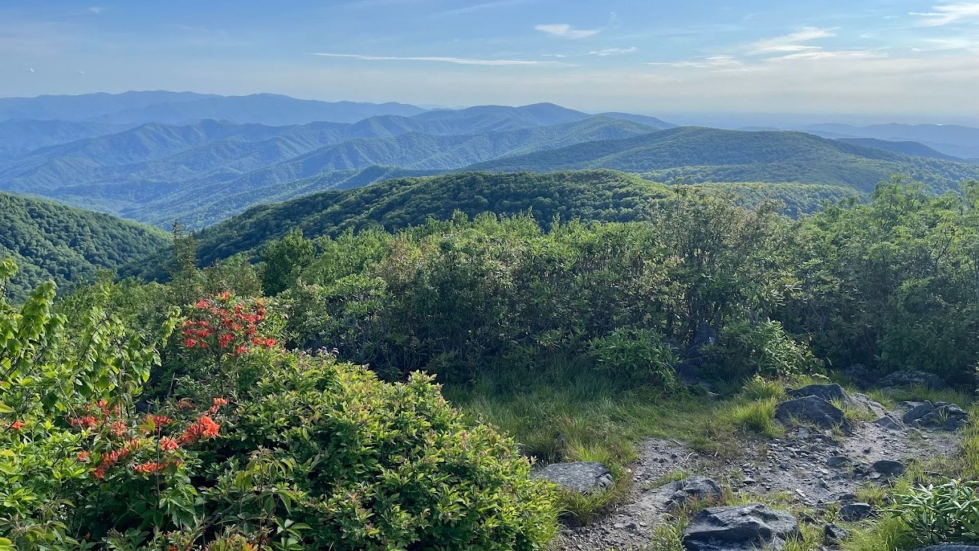
Few summits in the Smokies are as famous as Rocky Top. This rocky outcrop on the Appalachian Trail sits at 5,441 feet on the shoulder of Thunderhead Mountain, and it shares its name with one of Tennessee's best-loved songs.
The hike there is long and steep, but the reward is huge: open, 360-degree views across Cades Cove, the high peaks of the Smokies, and far into North Carolina. For strong hikers, it's one of the most memorable day hikes in the park.
Rocky Top hike at a glance
Distance: about 13 miles round trip
Climb: about 3,600 feet
Summit elevation: 5,441 feet
Difficulty: strenuous, full-day hike
Trailhead: Anthony Creek Trail at the Cades Cove Picnic Area
Pets: not allowed on this trail
Finding the Rocky Top trailhead
There's no single trail named "Rocky Top." The most popular route starts on the Anthony Creek Trail at the Cades Cove Picnic Area, near the entrance to Cades Cove and before the one-way Cades Cove Loop Road begins. From the Townsend Y, follow Laurel Creek Road toward the cove and look for the picnic area on the left.
Shorter option — the Lead Cove Trail, which starts on Laurel Creek Road before you reach the cove, makes the round trip about twelve miles, but it's just as steep.
Bring a parking tag — a national park parking tag is required for any vehicle parked longer than fifteen minutes. See our guide to where to buy a Smokies parking pass.
Start early — this is an all-day hike, and you'll want plenty of daylight for the trip back down.
What the hike is like
Anthony Creek Trail
The first three and a half miles follow Anthony Creek through shady forest of hemlock, hardwoods, and rhododendron. The climb is steady, and you'll gain about 1,800 feet before reaching the Bote Mountain Trail.
Bote Mountain Trail to Spence Field
The Bote Mountain Trail climbs another 1.7 miles to Spence Field on the Appalachian Trail. Spence Field is the largest grassy bald in the park. It was cleared by cattle grazing in the 1800s and is now partly overgrown. It's a great place to rest before the final push.
The Appalachian Trail to Rocky Top
From Spence Field, turn left onto the Appalachian Trail. The last stretch to Rocky Top is a little over a mile, steep and rocky with plenty of ups and downs. Then the trees open up, and you're standing on one of the best viewpoints in the Smokies.
The view from Rocky Top
On a clear day, Rocky Top's open, rocky summit gives you a full 360-degree view. Look down into Cades Cove and out to Gregory Bald, Mount LeConte, Kuwohi, and ridge after ridge reaching into North Carolina. Thunderhead Mountain, the highest point on the ridge at 5,527 feet, is about three-quarters of a mile further along the Appalachian Trail, but its summit is covered in rhododendron, so most hikers turn around at Rocky Top for the better view.
Tips for hiking Rocky Top
Carry plenty of water — water can be scarce up high, especially in dry weather. Bring more than you think you'll need.
Dress in layers — the summit is often windy and much cooler than Cades Cove.
Watch the weather — the exposed summit is no place to be in a thunderstorm. Turn back if storms roll in.
Plan overnight trips ahead — the Spence Field shelter on the Appalachian Trail requires a park backcountry permit and reservation.
Best time to hike Rocky Top
Spring — wildflowers bloom along Anthony Creek, and the views are crisp on clear days.
Summer — long days for a long hike, but start early to avoid afternoon storms.
Fall — some of the best leaf views in the park stretch out from the summit. Plan a leaf-season trip with our fall cabin rentals.
Winter can bring snow and ice up high. Check trail and road conditions with the national park before any visit.
More big hikes near Cades Cove
Looking for more adventure? Gregory Bald is famous for its June azaleas, and the Rich Mountain Loop starts right at the entrance to Cades Cove. Abrams Falls is a shorter waterfall hike in the cove, and our guide to the must-see sights along the Cades Cove Loop covers the rest. For another big summit view, try the fire tower on Mount Cammerer, or browse all our Smoky Mountain hiking trails.
Frequently asked questions
How long is the hike to Rocky Top?
About thirteen miles round trip from the Cades Cove Picnic Area via Anthony Creek, Bote Mountain, and the Appalachian Trail.
How high is Rocky Top?
Rocky Top sits at 5,441 feet on the shoulder of Thunderhead Mountain.
How hard is the Rocky Top hike?
It's strenuous, climbing about 3,600 feet. Plan for a full day.
Where does the Rocky Top hike start?
Most hikers start on the Anthony Creek Trail at the Cades Cove Picnic Area. The Lead Cove Trail on Laurel Creek Road is a slightly shorter option.
Is Rocky Top the same as Thunderhead Mountain?
Rocky Top is one of Thunderhead's summits. The true top of Thunderhead is about three-quarters of a mile further along the Appalachian Trail, but Rocky Top has the better view.
Can I bring my dog?
No. Dogs aren't allowed on these trails, including the Appalachian Trail in the national park.
Make Rocky Top the highlight of your Smoky Mountain vacation. Our cabins near Cades Cove and Wears Valley cabins put you close to the trailhead for an early start, and our mountain view cabins keep the views coming after the hike. Rest tired legs in one of our hot tub cabins, and if the dog is coming along, our pet-friendly cabins welcome them too.